 The Pacific War Online Encyclopedia
|
| Previous: Tarakan | Table of Contents | Next: Tarraleah |
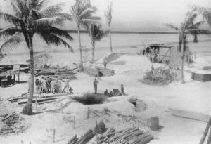
Captured Japanese
photograph, USMC. Via ibiblio.org
Tarawa (172.93E 1.36N) is an atoll of the Gilbert Islands group, located just north of the equator and southwest of Hawaii. The atoll is triangular in shape, with the east side 18 miles (29 km) long and the south side 12 miles (19 km) long. These are studded with islets, of which the most important was Betio at the southwest tip. All were planted with coconut palms. The west side of the triangle is barrier reef with a single deep, wide (1 mile or 1.6 km) pass. A small island near the center of the lagoon, Bikeman Island, is a remnant of the original volcanic island from which the atoll formed.
A coral gravel road ran the entire length of the atoll along the lagoon side.
The population of the atoll was 2700 Micronesians and about 30
Europeans. Most were evacuated before the Japanese arrived but a few
were interned.
Betio is elongated east to west, with a length of about 3800 yards (3500 meters) and a width of about 600 yards (550 meters). The total area was about 291 acres (118 hectares). No point on the island was higher than 10' (3 meters) and the only water supply was catchment basins and a few brackish wells. The island is surrounded by a wide reef, 500 to 1200 yards (460 to 1100 meters) across, and a sea wall surrounded most of the island at approximately the high tide mark. A long pier, Government Pier, extended 1600' (490 meters) across the reef on the north (lagoon) side of the island, where it provided a docking point for oceangoing ships. A second shorter (150' or 45 meter) pier, Burns Philp Pier, was located 400 yards (365 meters) to the east of Government Pier and was accessible only to small boats.
The atoll was visited by a small Japanese
force
on 10 December 1941, which rounded up a few Europeans and withdrew. A
permanent garrison did not arrive until 15 September 1942. The Japanese
subsequently constructed an airbase
on Betio, with a 4400'(1340 meter) runway and set of taxiways. The
native population of the island was relocated to other islands in the
atoll, where they were expected to fish for the Japanese as well as
themselves and provide occasional labor details to work on the defenses.
Battle
of Tarawa. The Japanese heavily fortified the
islet of Betio,
where the principal airstrip was located. There was a coconut log
barrier three to five feet (one to two meters) high behind the beaches, with
numerous machine guns sited
behind it. Many of the machine gun emplacements were covered with coconut logs, sometimes
supplemented with concrete or armor
plate. Including machine guns sited further inland for antiaircraft
defense, there were a total of 62 heavy machine guns and 44 light
machines guns on the islet. The islet was also defended by four 5.5"
(140mm) and four
8" (203mm) coastal defense guns. The 8" guns had been brought in from Singapore
and were emplaced, two at each end of the island, with large concrete
ammunition rooms. Further fire support was provided by 34 field guns:
six 70mm battalion guns, eight 75mm dual-purpose guns, 10 75mm mountain
guns, six 80mm guns, and four 5.1" (130mm)
dual-purpose guns. Most of these were emplaced in
well-constructed pillboxes. The four 5.1" guns and eight of the 75mm
guns were dual-use weapons with antiaircraft capability. There
were also nine 37mm antitank guns and fourteen light tanks armed with
37mm guns dug into the sand and camouflaged with palm fronds. Some of the bomb shelters on the islet had roofs six feet
thick made of sand, logs, and corrugated iron. There were an estimated
500 fortified positions of all sizes on the island. The airfield was protected by tank traps at its east and west ends.
The heart of the defending garrison was 1497 men of 7 Sasebo SNLF. These were reinforced with another 1122 men from 3 Special Base Force and 1247 men from 111 Pioneers, plus some 970 labor troops (over half Korean) of limited combat effectiveness. The troops had 7 light tanks at their disposal, but ammunition supplies were somewhat limited, at 4800 rounds of 75mm and 127mm antiaircraft ammunition and 15,000 rounds of 13mm machine gun ammunition. All these forces were under the command of Gilberts Area Defense Force (Keiji) with its headquarters on Betio.
Preinvasion reconnaissance was thorough and effective and determined that the Japanese defenses were oriented towards the south and west beaches of the islet. As a result, the decision was made to land on the lagoon side. However, the reefs here extend 300 to 500 yards offshore, and there was concern about whether the tides would be deep enough to allow landing craft to cross. Tides in this part of the Pacific are often erratic ("dodging tides") and no tide tables existed in 1944. Planners consulted former British residents of the atoll and concluded that there was a 2 in 3 chance of favorable tides on the proposed invasion date. Delaying the invasion meant a risk of westerly winds setting in that would make the invasion impossible, and Turner decided to take the chance.
The invasion force consisted of 2 Marine Division under Julian Smith. Smith planned to land artillery on Bairiki to cover the main landings, but Holland Smith insisted on holding 6 Marine Regiment in reserve, forcing Julian Smith to commit his two remaining regiments to a direct frontal assault. On the other hand, Holland Smith argued furiously with Turner for an increased allotment of LVTs to carry the Marines over the fringing reef in case the tides proved unfavorable. Although the number allocated was still insufficient, and most of the Marines would still have to go in aboard conventional landing craft, the increased allotment of LVTs would prove crucial in the battle.
The landings began on 20 November 1943 and immediately ran into trouble. Turner had lost his gamble on the tides, one of the few instances of bad luck in an otherwise lucky career. Many of the landing craft were stranded on the reef by an unusual low tide. Their passengers had to wade ashore under withering fire from the defenders and suffered terrible losses. Many of the American naval commanders believed that their preliminary bombardment, which placed 3000 tons of shells on the island, would leave nothing but a few shocked survivors to be mopped up; this proved grossly optimistic, as most of the Japanese fortifications were still intact. (Several Marine officers were much less optimistic.) The 3500 Marines who made it ashore (out of 5000 in the first day's landing waves) were pinned down on the beaches by intense machine gun and small arms fire.
Not all the luck was with the Japanese, however. Admiral Keiji was killed by artillery fire early in the battle. His death, and the disruption of the island communications network from the bombardment, meant that no counterattack could be organized while the Americans were still vulnerable.
The next day, tanks and additional troops came ashore and began rolling up the Japanese from the western tip of the island. The tide finally rose over the reef and the remainder of the division was able to swarm ashore. By the 22nd the battle was no longer in doubt, and the island was declared secure at noon on the 23rd. The Marines had suffered 3234 casualties, including 984 dead and 88 missing, while the 4836 Japanese defenders were virtually wiped out. Only 17 wounded soldiers and 129 Korean laborers survived to be taken prisoner.
Following the battle, American engineers further developed the
airfield, which was operational on 18 December 1943. By 1 January 1944
there were two runways 6600' (2010 meters) long and a new 6000' (1800m)
runway on Buota islet. These airfields
proved valuable for staging bomber
raids on the Marshalls.
References
The Pacific War Online Encyclopedia © 2007-2008, 2010 by Kent G. Budge. Index