 The Pacific War Online Encyclopedia
|
| Previous: New Almaden | Table of Contents | Next: New Caledonia |
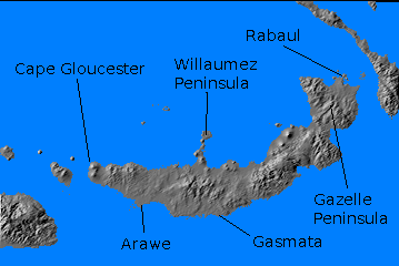
Besides being jungle-clad, the island is rugged, with a central mountain range along most of its length that reached to just over 6000' (1800 meters). This included several active or dormant volcanoes, of which The Father (Mount Ulawan) was the highest at 7657' (2334 meters). The anchorage at Rabaul is a flooded caldera, and resurgent domes in the harbor area emitted quantities of steam and ash from time to time. Sulfurous fumes greatly reduced the habitability of the many underground fortifications build here by the Japanese during the war. Much of the coastline was backed by swamps whose trees grew to 100' (30 meters). Although there are numerous beaches suitable for landing, most of the coastline is fringed with reefs.
The native
population in 1940 was estimated at 101,000 and the number of Europeans
and Asians at 4674.
Rabaul was seized by the Japanese on 23 January 1942 and rapidly
developed into a major base. By 1943 the garrison numbered 80,000 to
90,000 men, mostly deployed around the Gazelle Peninsula, with about
7500 troops defending the 3900' (1200 m) airstrip on Cape
Gloucester on the western end of the island. The Japanese
eventually built three new airfields in the Rabaul area and
established forward airfields at Gasmata,
on
the
south coast; at Ubili (151.261E 5.002S) on the northeast coast; at Cape Hoskins (150.432E 5.438S) on
the north-central coast; and at two locations at Cape Gloucester on the
western tip of the island.
MacArthur
had called for an offensive against Rabaul almost from the time he
arrived in Australia.
However, Allied
planners chose instead to first encircle the base from east and west.
As the war progressed, and it became clear how formidable a
fortress the Japanese had made of Rabaul, the Allies contented
themselves with smashing the base from the air, then bypassing
it by
seizing control of the Vitiaz and Dampier Straits between Cape
Gloucester and the Huon Peninsula of New Guinea. By December 1943 the
Allied airfields in the Markham and Ramu Valleys, west of Lae on New Guinea, were fully operational
and 5 Air Force
was able to guarantee air superiority over western New Britain.
Arawe. As part of the encirclement strategy, landings were made along the western half of New Britain, beginning with 112 Cavalry Regiment at Arawe on 15 December 1943. Arawe was located on the south coast of New Britain about 60 miles (100 km) from Cape Gloucester. It boasted a small anchorage, suitable only for shallow-draft vessels; a plantation; and an unused airstrip. The anchorage was the main objective, since MacArthur claimed it would be useful as a base for PT boats (in spite of objections from the PT commander), but the real purpose of the landings at Arawe was to provide a diversion.
Arawe had been raided the day before the landings by 5 Air Force, which dropped 433 tons of bombs on the area. The cavalry troopers had had no prior training in amphibious assault and had just ten days to rehearse at Goodenough Island. The landing force consisted of LSD Carter Hall, APDs Humphreys and Sands, and Australian LSI Westralia escorted by destroyers and given air cover by Navy Black Cats. Landings commenced at 0330 and Pilelo Island, covering the main channel into the anchorage, was seized almost at once. However, a second landing group found itself at the head of a cove covered by cliffs where the Japanese had sited several machine guns. The navy commander had declined to bombard the area, in hopes of achieving surprise, but the Japanese had detected the activities of American amphibious scouts in the area and were fully alerted. Twelve of the fifteen landing boats were destroyed but most of the men were able to swim back to sea to be picked up by SC-699. The main landing force was equipped with LVTs and was supported by a raid by B-25s from Dobodura. The troops were ashore by 0723 and quickly secured the beachhead. A strike by 8 Vals and 56 Zeros from Rabaul broke through the 16 defending P-38s but inflicted no damage.
By nightfall over 1900 troops were ashore, but the
supply echelons arriving in the
following days came under heavy air
attack. 5 Air Force was occupied elsewhere and the warships were forced
to rely on their own antiaircraft
for protection. A coastal transport
was sunk and seven other ships
were
damaged, but this did not prevent the supply ships from landing 6287
tons of supplies and 451 guns
and vehicles in the next three
weeks. By
contrast, just 35 troops were killed
ashore. A weak counterattack by
Japanese support troops on 25 December was easily repelled.
Cape Gloucester. The landings at Cape Gloucester were carried out by 1 Marine Division (Rupertus) on 26 December 1943. The terrible weather conditions proved more memorable for many Marines than the Japanese resistance. Hot food was impossible to prepare in the downpour, and Marines hoarded the waxed paper and cardboard from K ration containers as a source of fuel for heating coffee. Anything made of leather quickly developed a layer of blue mold that had to be scraped off every day. It was impossible for the Marines to keep their feet dry, and trench foot became a serious problem.
MacArthur believed the Cape Gloucester landings were necessary to secure Dampier Strait between New Britain and New Guinea and helped close the noose on Rabaul. However, Morison has argued that the landings were unnecessary, since the Japanese force at Cape Gloucester had no artillery with which to close Dampier Strait, and Vitiaz Strait between Finschhafen and Rooke Island was a better channel for shipping in any case. However, this was not obvious at the time.
Allied units would continue to probe up the island
of New Britain as the
Japanese withdrew into their fortress for the
remainder of the war. On 23 February 1944 17 Division was ordered to make
a fighting withdrawal to to the base of the Willaumez Peninsula and
hold open the retreat of Matsuda
Force, which was withdrawing from Cape Gloucester. The Marines
attempted to cut off these forces with a landing by 5 Marine Regiment on the Willaumez
Peninsula on the same day to seize the anchorage at Garua Harbor, but
were unable to move fast enough to prevent 17 Division
escaping into the
Gazelle Peninsula. Leckie (1962) has criticized the Willaumez operation
as pointless, since the local airstrip was barely large enough for liaison aircraft, Matsuda Force
was completely spent, and the Marines already controlled every point of
any military value in western New Britain. On the positive side,
Talasea proved to be nearly a tropical paradise, cooled by breezes off
Garua Harbor and with significant local facilities, including St.
Boniface Mission Church.
References
The Pacific War Online Encyclopedia © 2007-2008, 2010-2011 by Kent G. Budge. Index