![]() The Pacific War Online Encyclopedia
The Pacific War Online Encyclopedia
|
| Previous: Naze | Table of Contents | Next: Negeshi Yon |

Ndeni (165.925E
10.775S) is the principal island of the Santa Cruz group
east of the Solomons.
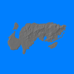
It is roughly 25 miles (40km) long and 14 miles (22 km) wide with a total area of 200 square miles (519 km2). The mountainous interior reaches to 1696' (517m) above sea level, but there is a high, relatively flat plateau at the west end of the island.
The island had no facilities in 1941. However, its strategic location during the Guadalcanal campaign led the United States to attempt to build an airbase here. The attempt was abandoned in part because of limited resources and unfavorable terrain and in part because the island was infested with a vicious strain of malaria that made it all but uninhabitable to Westerners.
Turner
originally planned to occupy Ndeni with 2
Marine Regiment two days after the landings at Guadalcanal.
However, the unexpectedly stiff resistance at Tulagi and its neighboring islets
forced Turner and Vandegrift
to commit 2 Marines there instead. Destroyer-seaplane tender
McFarland
operated a squadron of PBY
Catalina flying boats
from the anchorage until ordered to withdraw following the Savo Island debacle. The U.S.
continued to operate Catalinas from time to time from Ndeni, and they
played an important reconnaissance
role during the battles of Eastern
Solomons and Santa Cruz.
References
SolomonIslands.com.sb (accessed 2011-8-21)
The Pacific War Online Encyclopedia © 2010 by Kent G. Budge. Index