 The Pacific War Online Encyclopedia
|
| Previous: Manchuria | Table of Contents | Next: Mandates |
Imperial War
Museum. Via Wikimedia
Commons
Mandalay (96.094E 21.948N) is the communications center of upper Burma, with one of the few all-weather runways in Burma in 1941. It is located in the Burmese dry zone and the surrounding agricultural region must be irrigated. Rice, cotton, peanuts, and beans are produced. It is an important river port on the Irrawaddy River.
The modern city was built in 1856-1857 by King Mindon Min, near the "Immortal City" of Amarapura, which had been founded in 1783 and was the capital of Burma until 1859. Mandalay became the new capital and remained so until 1885. The central part of the city was within a walled enclosure called Fort Dufferin. Mandalay Hill, reaching to 790' (240m), is located just north-northeast of Fort Dufferin and commands the area. There are literally hundreds of Buddhist pagodas and monasteries in the area.
Following the loss of Yenangyaung, the British could no longer supply their forces in Burma and concentrated on protecting their line of retreat, leaving Mandalay to fall to the Japanese
on 1
May 1942.
Allied forces returned to Mandalay in early 1945. 19 Indian Division (Rees) crossed the Irrawady north of Mandalay on 7-11 January 1945 and successfully beat off a series of counterattacks. As Kimura redeployed against this threat, on 14 February 1945, 20 Indian Division (Gracey) crossed the Irrawady just south of Mandalay, at Myinmu (95.583E 21.933N). On 24 February 2 Division crossed the Irrawady just upstream of 20 Indian Division, at Ngazun (95.687E 21.898N)
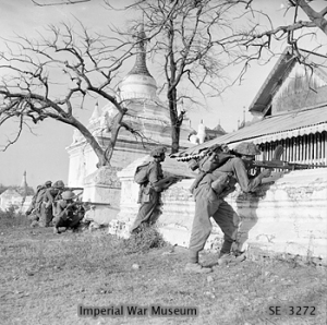
Rees raced his division towards the city, leading quite literally from the front, and at one point ordering three trucks driven into a ravine so that his tanks could go across on top of them. So confident was he that his momentum would take him into the city that he detached 62 Indian Brigade to take Maymyo to the east. By 7 March his lead tanks were five miles north of the city and could see Mandalay Hill. However, the defending 15 Division had orders to defend the city to the death (to the disgust of its commander, Yamamoto Seiei) and the Japanese would fight fanatically for the city.
98 Indian Brigade began its assault on Mandalay Hill, defended by 67 Regiment, on 8 March 1945. An officer familiar with the area had taken a force of Gurkhas up the hill the previous evening under cover of darkness, and the summit was taken in a dawn attack. However, it took another four days for the Allied troops to burn the remaining Japanese out of the numerous fortifications on the hill, using drums of gasoline poured through openings blown out with point-blank fire from antitank guns.
With Mandalay Hill secured, the British began reducing Fort Dufferin. This was a formidable position, 2000 yards (1830m) square, surrounded by masonry walls tapering from 30' (9m) at the base to 12' (3.6m) at the top, which reached 23' (7m) high. Behind the walls were earth ramparts, and the whole was surrouned by a 75' (23m) moat crossed by five bridges. The British blew breaches in the walls with 5.5" (140mm) howitzers and Thunderbolts bombed the south bridge,but the earth ramparts behind the walls absorbed the shells and Japanese antitank guns drove back the British tanks.
Rees was determined to capture Fort Dufferin without suffering the heavy casualties the Chinese and American forces had suffered taking Myitkyina. He first attempted "Exercise Duffy", an attempt to seize a bridgehead in the fortress by surprise at night. However,
surprise was not achieved, automatic weapons fire drove back the
British, and Rees called off the operation before daylight exposed his
men to lethal fire. Rees then began plans to take the fortress by
infiltration through the sewers beneath it, but on 20 March 1945 the
British discovered that the Japanese abandoned the fortress through the same system of sewers the previous night.
The loss of Mandalay disrupted the Japanese supply lines to 15 and 33 Armies and the simultaneous capture of Maymyo isolated 56 Division to the east. Its recapture was a blow to Japanese prestige and strained their relations with Burma National Army.
Climate Information:
Elevation 252'
Temperatures: Jan 82/55, Apr 101/77, Jul 93/78, Oct 89/73, record 111/44
Rainfall: Jan 0.1/0.1, Apr 2/1.2, Jul 6/2.7, Oct 7/4.3 == 32.6" per annum
Peak Jun 7/6.3
References
The Pacific War Online Encyclopedia © 2007, 2010-2011 by Kent G. Budge. Index