 The Pacific War Online Encyclopedia
|
| Previous: Honolulu | Table of Contents | Next: Hoover, John H. |
Honshu is the largest of the Japanese
home islands, with a land area of about 89,000 square miles (230,000 km2).
Its
climate
varies from cool in the north to nearly subtropical in the south, but
the
entire island receives ample rainfall and is lushly
vegetated.
Unfortunately, it is also very mountainous,
with
little arable land,
though the
existing farmland is very productive. Navigable waterways are
almost
nonexistent, and though the island had a modern rail system in 1941,
the total
rail mileage was quite small, and the Japanese were heavily dependent
on
coastal shipping. This would
prove disastrous during the American
aerial
mining campaign of 1945.
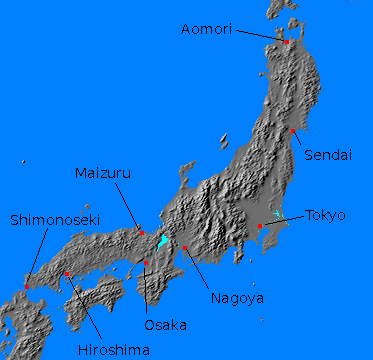
Major cities on the island included Tokyo, Nagoya, Osaka, and Sendai. There were important naval bases at Yokosuka, at the entrance to Tokyo Bay; Kure, near Hiroshima; Maizuru on the Sea of Japan; Aomori commanding Tsugaru Strait; and Shimonoseki on Shimonoseki Strait. There were many lesser ports and cities, particularly on the Inland Sea between Honshu and Shikoku, and numerous airfields.
The heart of Japan was the Kanto Plain surrounding Tokyo Bay. Had the Allies actually carried out
their plans to invade Japan, this
area would have been the target of the second phase of the invasion,
CORONET. The projected date for CORONET was 1 March 1946,
and the operation would have been carried out by 8 and 10 Armies with a
total of fourteen divisions.
These would be joined later by 1 Army with
ten more divisions. Four more divisions were to be held in reserve. However, the American use of nuclear weapons, combined with
the Russian invasion of Manchuria, prompted the Japanese surrender without an invasion.
References
Frank (1999)
The Pacific War Online Encyclopedia © 2007, 2010, 2012 by Kent G. Budge. Index