 The Pacific War Online Encyclopedia
|
| Previous: Esperance | Table of Contents | Next: Essex Class, U.S. Fleet Carriers |
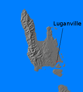
Espiritu Santo (167.185E
15.529S) is the largest island of the New Hebrides group, extending 75
miles (120 km) north to south along its west coast and 45 miles (70 km)
from east to west for a total land area of 1550 square miles (3880 km2).
It had
an excellent but almost
completely undeveloped harbor at
Luganville in
1941. The western half of the island is mountainous with a maximum
elevation of over 5500 feet (1670 meters). The eastern half is somewhat
less rugged but with a number of limestone ridges, former reefs exposed by tectonic uplift. The
climate is very damp, with an average annual rainfall of 90 inches (230
cm), and the entire island is jungle-clad
except where the land had been cleared for cultivation. The population
was some 4000 natives
and 900 Europeans, and the island had significant agricultural
production of copra, coffee, sugarcane, cotton, rice, and tropical fruit. The
plantations were concentrated in the southeast of the island and the
adjacent smaller islands.
Because of its strategic
location, halfway
between New Caledonia and
the Solomons, the island
became a
major Allied base during
the Guadalcanal campaign. An
advance force from Efate arrived on
28 May 1942 and 3
Naval Construction Battalion began landing in large numbers
beginning on
12 August 1942. The initial airfield
site, at Turtle Bay twelve miles (19 km) north of Luganville, proved
problematic, and a landing strip was barely ready by 7
August 1942, the day of the Guadalcanal invasion. Ultimately
Turtle Bay
had 6000' (1830 meter) and 4500' (1370 meter) runways, and by November
1942 there was a 6000' (1830 meter) runway two miles west of Luganville
and a 7000' (2130 meter) runway four miles east of Luganville. In early
1943 a fifth runway 6800' (2070 meters) long was built outside
Luganville.
The Allies
initially tried to keep the existence of the base secret, by analogy
with Base "T" (Addu Atoll) in
the Indian Ocean. However, a
seaplane from I-24 discovered the airfield on
2 October 1942.
Segond Channel south of Luganville is deep and
well-protected and was heavily developed during the war. It became the
largest operating base in the South Pacific and remained important to
the end of the war. Before the base was dismantled on 12 June 1946,
hundreds of vehicles were dumped into the harbor because they would
have cost too much to ship home.
References
Boyd
and Yoshida (1995)
Huie (1944)
The Pacific War Online Encyclopedia © 2007-2010 by Kent G. Budge. Index