 The Pacific War Online Encyclopedia
|
| Previous: New Hebrides | Table of Contents | Next: New Mexico Class, U.S. Battleships |
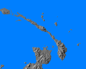
New Ireland is the second largest island in the Bismarck Archipelago, about 200 miles (320 km) in length and from eight to twenty miles (13 to 32 km) wide, with an area of 3,340 square miles (8,650 km2). It is located northeast of New Britain and northwest of the Solomon Islands and shares the terrible jungle terrain of both. There was a good but undeveloped anchorage at Kavieng on the northwest tip of the island, but this tended to be overshadowed by the superb anchorage at Rabaul, on the northeastern tip of New Britain. Besides being jungle-clad, New Ireland is rugged, though it has not experienced any historical volcanic eruptions, and its highest point reaches 7053 feet (2150 meters). The mountains drop steeply into the ocean along the southwest coast, but descend more gradually to the northeast, where there is a narrow coastal plain.
The indigenous population numbered about 54,000 persons speaking over 45 different dialects. There were about 200 European residents.
The island was occupied by elements of 2 Maizuru SNLF (500 men) beginning on 23 January 1942. Eventuall the Japanese build three additional airstrips, one south of Kavieng and at Namatani (152.45E 3.66S) and Borpop (152.81E 3.88S)
References
The Pacific War Online Encyclopedia © 2010 by Kent G. Budge. Index