 The Pacific War Online Encyclopedia
|
| Previous: Woodlands | Table of Contents | Next: Woodruff, Roscoe B. |
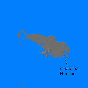
Woodlark Island (Muyua; 152.76E 9.15S) is an island northeast of the eastern tip of New Guinea. The island is 44 miles (71 km) long and 20 miles (32 km) wide. Although ringed by reefs, it has a number of anchorages along its south coast, including Guasopa Harbor in the southeast, which could only be approached through two channels through the reef. Though relatively flat, there is some hilly terrain in the south, and most of the south coast is fronted by cliffs. The island is covered with jungle and had few inhabitants.
Guasopa Harbor was occuped in 23 June 1944 by 2600
troops of 112
Cavalry Regiment, 134
Field Artillery Battalion, and 12
Marine Defense Battalion. The troops were brought in on 6 APDs, 6 LCIs, and 6 LSTs
and had no dedicated air cover, although fighters were on standby on
nearby Allied airfields, and the landings were timed so that the
landing force would have of darkness when beyond easy fighter range.
However, the landings were opposed only by Australian coast watchers, who had not gotten word of the landings and who narrowly avoided a friendly fire incident when they heard the unidentified troops coming ashore speaking American English.
A 3000' (915 meter) runway was ready by
14 July. This was extended to 6500' (1980 meters) by September.
However, the airfield was never
used for anything but local defense.
References
The Pacific War Online Encyclopedia © 2010 by Kent G. Budge. Index