 The Pacific War Online Encyclopedia
|
| Previous: Walker, Kenneth N. | Table of Contents | Next: Walrus, British Reconnaissance Seaplane |
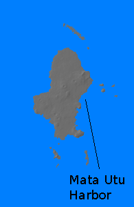
Uvea (176.182W, 13.294S) is the principal island of the Wallis group, but it was known to U.S. forces during the war as Wallis Island. It is located 250 miles (400 km) west of western Samoa and 490 miles notheast of Fiji. The main island is about eight miles (13 km) long and five miles (8 km) wide and is enclosed within a reef. It is a relatively flat island, with a maximum elevation of 476' (145 meters) in spite of geologically recent volcanic activity. The soil is fertile and the island covered with jungle. There were undeveloped anchorages at Mua Harbor, south of the island, and at Mata Utu harbor to its east enclosed by the reef and somewhat protected by islets. Both anchorages were reached through Honikulu Passage on the south side of the reef. There are two additional deep passes on the west of the reef.
The population in 1940 was 300 French and 4200 Polynesians. The
only product of importance was copra
and Mata Utu Harbor had only the barest facilities. Elements of 8
Marine Defense Battalion and a battalion from 7
Marine Regiment arrived on 29 May 1942 to garrison the
island. These were followed in June by Seabees who began construction
of a 6000' (1830 meter) runway,
completed in October. This was followed by a 5000' (1520 meter) fighter runway. The base was
closed in July 1944.
References
The Pacific War Online Encyclopedia © 2010 by Kent G. Budge. Index