 The Pacific War Online Encyclopedia
|
| Previous: Sakanichi Ichiro | Table of Contents | Next: Sakonju Naomasa |
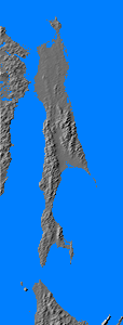
Sakhalin was the Russian
name for the island the Japanese
knew as Karafuto, which lies just north of Hokkaido across La Perouse Strait. The island is 560 miles (900 km) long and up to 60 miles (100 km) wide, with an area of 30,000 square miles (78,000 km2). It is mountainous and forested, with considerable swampy ground.
The valley of the Tym' and Poronai Rivers forms the chief communication
corridor between north and south, and the Japanese placed most of their
defenses here, around the town of Koton (Pobedino; 142.828E 49.843N).
The Japanese controlled the southern half of Sakhalin and the Russians
the northern half. The northern half was the real prize, with
significant oil
fields at Ekhabi and Okha.
The Japanese had oil concessions here, and in 1940 they unsuccessfully
tried to persuade the Russians to sell them the northern half of
Sakhalin.
During the last days of the war, Russia seized the Japanese half of the island. It remains in Russian hands today.
References
The Pacific War Online Encyclopedia © 2006, 2012, 2014 by Kent G. Budge. Index