 The Pacific War Online Encyclopedia
|
| Previous: Hawaii | Table of Contents | Next: Hawker Aircraft Ltd, |
Hawaii Island is the largest and easternmost of the Hawaiian Islands with an
area of 4028 square miles (10,432 km2). The island is mountainous,
with the 13,796' (4025 m) Mauna Kea in the north and 13,679' (4169 m)
Mauna Loa in the south. Both are volcanic, and although Mauna Kea has
not erupted in historic times, Mauna Loa erupted in 1942. Hualalai on the west coast last erupted in 1801, while Kilauea
southeast of Mauna Loa is one of the most active volcanoes in the
world. The recent volcanism means that the island has relatively smooth
terrain except in the more ancient northern tip of the island.
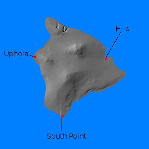
In spite of the threat of volcanism, the island had a significant port at Hilo and military airstrips had been constructed there and at Uphola and South Point. There was significant agriculture, including the massive Parker Ranch, which later hosted Camp Tarawa, a Marine Corps camp located in the saddle between Mauna Kea and Mauna Loa and capable of basing a division.
The camp location was chosen in part because the higher altitude meant
a cooler environment more conducive to recuperating from malaria.
References
Binckley (2006; accessed 2011-6-29)
The Pacific War Online Encyclopedia © 2011 by Kent G. Budge. Index.